Furnace 508 Race Route - CONTENT STILL NEEDS TO BE REPLACED
![]() This 508 mile bicycle race is revered the world over for its epic mountain climbs, stark desert scenery, desolate roads, and its reputation as one of the toughest but most gratifying endurance challenges available, bar none.
This 508 mile bicycle race is revered the world over for its epic mountain climbs, stark desert scenery, desolate roads, and its reputation as one of the toughest but most gratifying endurance challenges available, bar none.
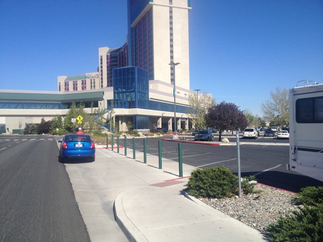
In 2014, The 508 moved to Nevada and is based at the Atlantis Casino Resort!
We are EXTREMELY excited about and pleased with this route and the overall experience of hosting an event of this caliber, size, and scope in Reno and across the great state of Nevada!
Your race director, Chris Kostman, has personal experience with this route, because he raced across Nevada on Hwy 50 in the 1987 Race Across American and LOVED it!
Support vehicles and crews will be required (ecept for the new solo randonneur self-supported division) and the race rules are extremely similar to the rules we have used in the past. Notably different, support vehicles will direct-follow their rider on the return / westbound leg only, and only at night.
Silver State 508 Route Information and Links
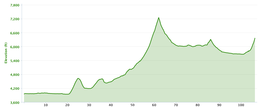
Overall Stats: 510.40 miles / 20,000 feet of gain and loss / 4000' min altitude / 7500' max altitude
Download the ten-page route sheet as a PDF
Route Details, Elevation Profiles, and Garmin / Map Links
Relay Racing Stats: Data for each rider on 2x and 4x teams
Some Comparative Notes: Silver State 508 vs Furnace Creek 508
Notable Elevations and Passes Over Which the Route Crosses
Silver State 508 Written Route Description by Rebecca Eckland with Photos
Downloadable Excel (.XLSX) file of the Route
Images and Videos of the 2014 Route
Route Details, Elevation Profiles, and Map Links
Overall Map of Route and GPS file on RidewithGPS.com
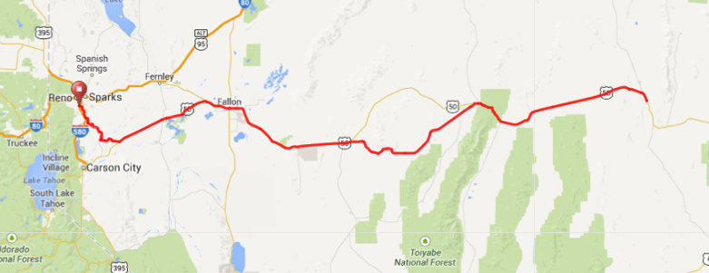
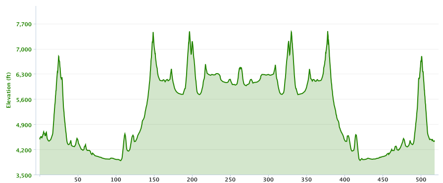
Above: Map and Elevation Profile for the Silver State 508
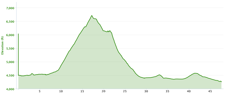
Stage One: Reno to Geiger Grade to Virginia City to Silver Springs
47.65 miles / 2723' elevation gain / 2959' elevation loss / 4257' min altitude / 6710' max altitude
Map and Garmin file
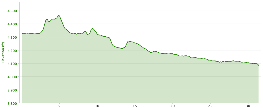
Stage Two: Silver Springs to Fallon
31.39 miles / 266' elevation gain / 489' elevation loss / 4084' min altitude / 4462' max altitude
Map and Garmin file
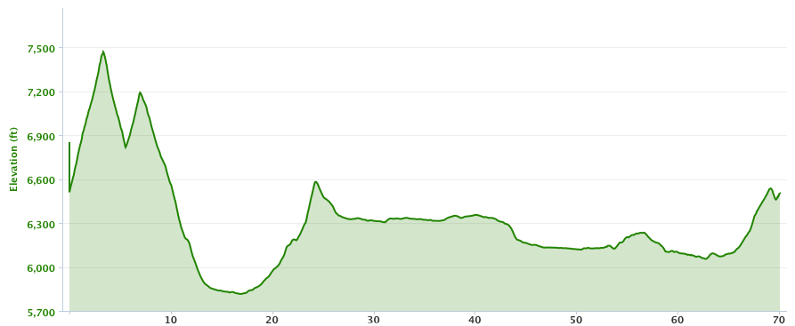
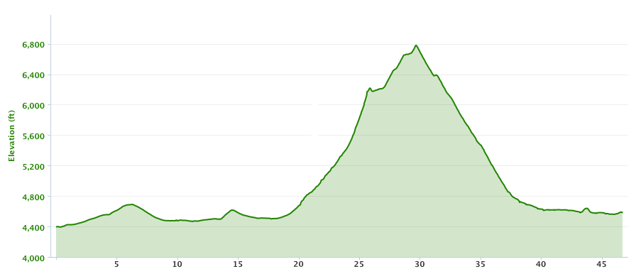
Stage Three: Fallon to Austin
106.41 miles / 5049' elevation gain / 2661' elevation loss / 3940' min altitude / 7245' max altitude
Map and Garmin file
Stage Four: Austin to Eureka
70.10 miles / 2799' elevation gain / 2729' elevation loss / 5816' min altitude / 7470' max altitude
Map and Garmin file
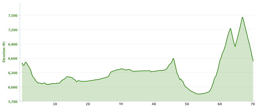
Stage Five: Eureka to Austin
70.09 miles / 2753' elevation gain / 2733' elevation loss / 5848' min altitude / 7556' max altitude
Map and Garmin file
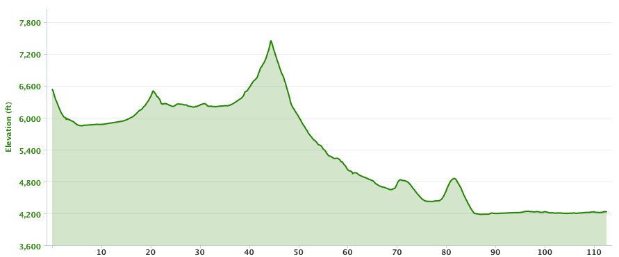
Stage Six: Austin to Fallon
112.53 miles / 2730' elevation gain / 5036' elevation loss / 4180' min altitude / 7446' max altitude
Map and Garmin file
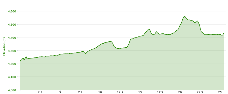
Stage Seven: Fallon to Silver Springs
25.47 miles / 499' elevation gain / 292' elevation loss / 4221' min altitude / 4560' max altitude
Map and Garmin file
Stage Eight: Silver Springs to Virginia City to Reno
46.85 miles / 3804' elevation gain / 2802' elevation loss / 4222' min altitude / 6832' max altitude
Map and Garmin file
Relay Racing Stats
Two-Person Relay Data
A Rider = Stages 1, 3, 5, and 7 = 249.62 miles
B Rider = Stage 2, 4, 6, and 8 = 260.74 miles
Four-Person Relay Data
A Rider = Stages 1 and 5 = 117.74 miles
B Rider = Stages 2 and 6 = 143 miles
C Rider = Stages 3 and 7 = 133 miles
D Rider = Stages 4 and 8 = 112 miles
Some Comparative Notes: Silver State 508 vs Furnace Creek 508
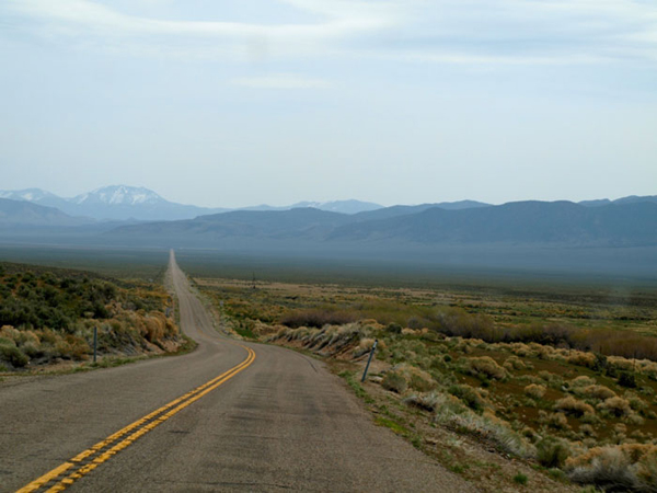
The route is often very similar to the Furnace Creek route: vast open spaces, mountainous desert, roads that stretch into infinity, and such. The route even crosses the Shoshone Mountains, and a huge sand mountain similar to the sand dunes near Stovepipe Wells. There are stretches that look just like the FC508 route near the Trona Pinacles, and just like the FC508 route between Amboy and Sheephole. That said, in comparing the Silver Stage route to the FC508 route:
- Our host hotel is much cheaper at the start/finish line, and also much bigger with multiple restaurants inside or within a few blocks.
- You finish lwhere you started in Reno, making for easier logistics. (You can leave bike boxes and luggage at the start line. Also, crews and riders can meet up at the start in multiple cars, and not have to drive hours to go fetch their cars after the race.)
- Gas averages 30 to 50 cents a gallon less than California, even out in the boondocks, where it is still cheaper than California cities and is is DOLLARS less than in Death Valley.
- The route is much easier to navigate (most of the route is either Hwy 50 or SR 772).
- There is far less traffic. (Highway 50 is known as "The Loneliest Highway in America.")
- The pavement is generally far better. There is essentially no terrible pavement. Most of it's great. There are long stretches with an actual shoulder.
- Cell coverage is available (at least for Verizon and AT&T customers) on 80-90% of the course.
- It passes through three scenic, photogenic Authentic Western Frontier towns a total of five times: Virginia City, Austin, and Eureka.
- These and the few other towns along the route offer far more amenities than the previous route, but are still small and easy to pass through.
- Wildlife abound next to, and sometimes on, the route: wild horses, wild burros, pronghorn antelope, bighorn sheep, plus cattle, sheep, and horse ranching.
- Though there is less climbing, it's at much higher altitude: never lower than 3940', but goes as high as 7490'.
Notable Elevations and Passes Over Which the Route Crosses
- Start Line: 4580'
- Geiger Summit 6789' (Stage 1)
- Sand Springs Pass 4644' (Stage 3)
- Drumm Summit 4600' (Stage 3; faux climb)
- Carroll Summit 7214' (Stage 3)
- Railroad Pass, Shoshone Mountains 6465' (Stage 3)
- Austin Summit 7484' (Stage 4)
- Bob Scott Summit 7210' (Stage 4)
- Hickson Summit 6546' (Stage 4)
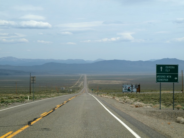
- Turn-Around in Eureka: 6481' (End of Stage 4; Start of Stage 5)
- Hickson Summit 6546' (Stage 5 - return)
- Bob Scott Summit 7210' (Stage 5 - return)
- Austin Summit 7484' (Stage 5 - return)
- Railroad Pass, Shoshone Mountains 6465' (Stage 6 - return)
- Carroll Summit 7214' (Stage 6 - return)
- Drumm Summit 4600' (Stage 6 - return; faux climb)
- Sand Springs Pass 4644' (Stage 6- return)
- Up Six Mile Canyon to Virginia City 6170', then over Geiger Summit 6789' (Stage 8 - return)
- Finish Line: 4580'
Silver State 508 Route Description
By Rebecca A. Eckland (For her post-race observations, click here.)
Stage 1: Reno to Silver Springs
The first leg of the race is 47.65 miles long and has 2723 feet of elevation gain. The race begins at Reno’s Atlantic Casino and heads south to state route 341, or Geiger Grade, which, beginning at mile 8.60, ascends into the red hills of Virginia City. The climb is a winding two-lane highway with a constant 5-8% grade, a favorite of Reno area cyclists. This historic road began as a toll facility which connected the wealth of the Comstock Lode to Reno. Riders will reach Geiger Summit, which sits at 6,889 feet elevation, after 8.75 miles of climbing with 2100 feet of elevation gain, before a winding descent into Virginia City. Originally founded for gold, Virginia City forged its name in silver mines, a town nestled into the shaded alcove of tall, barren hills. The town itself rests at 6,200 feet elevation and so the air nearly always carries a chill.
After a short cruise through the western storefront downtown, riders will begin the descent down Six-Mile Canyon, a canyon of steep walls, mine relics and cottonwoods The site where many of Nevada’s first mineral claims where made, this is arguably where Nevada became a state. When riders exit the canyon, they will have descended 2000 feet as the canyon road gives way to Highway 50. This is a fast, flat stretch of state highway with wide shoulders, leading to the first time station in Silver Springs.
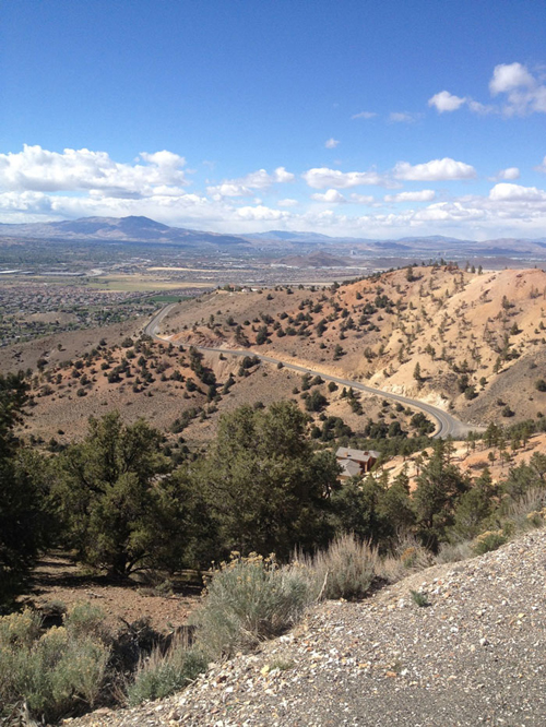
Above: the first big climb of the race is at mile 9: the Geiger Grade
Stage 2: Silver Springs to Fallon
Heading north and then east, Highway 50 leads riders of the 508 in the basin of what was once an ancient alkaline lake, Lake Lahontan, underscoring the stark nature of contrasts. This prehistoric ocean is only visible in the cliff faces high above the road were the ancient shoreline weathered the constant lapping of waves. What was once a completely aqueous environment is now its opposite, dry rock and sand, covered in brush. During this second stage of the race, riders will cover 31.35 miles, gaining a mere 266’ in elevation while descending 489’. Fallon is the largest city on the race route with myriad services available, while the time station, located about five miles east of town, has gas and the usual mini-mart fare.
Stage 3: Fallon to Austin
Shortly after leaving Fallon, riders will see Grimes Point, an archeological point of interest which reveals the lifestyle of early human inhabitants in the area by the petroglyphs they left behind. This stage begins to gain elevation at approximately the 25-mile mark when riders will ascend Sand Springs Pass, followed by a quick descent.
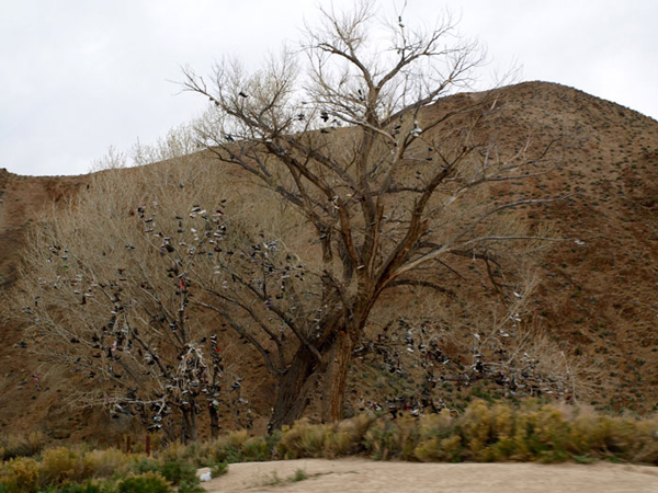
Above: the Shoe Tree on Stage Three and Stage Six
After passing the "shoe tree" and Middlegate Station, the riders next veer off highway 50 onto highway 722, a road that is, amazingly enough, even quieter than Hwy 50. Here the riders pass Eastgate Ranch as they begin their ascent to Carroll Summit, a favorite with cyclists who know the Great Basin. A 14-mile climb, Carroll Summit is known for its physical challenge (a 2000 foot ascent to an elevation of 7,214 feet) as well as for its desolation: you’re lucky if you see a single car out there.
Above: Looking west at the lower part of the Carroll Summit ascent on SR 722 during
stage three of the Silver State 508.
The majority of the climbing in this stage ends by mile 100 when riders leave the Desatoya Range, pass by the Yomba Shoshone Indian Reservation and climb into the Shoshone Mountains, home of Berlin, originally a mining town. Miners here used "round rocks" for dinner tables which turned out to be the fossilized vertebrae of an Icthyosaur, a dolphin-like creature which inhabited prehistoric Lake Lahotan. Today Berlin is home to Icthyosaur State Park, and the Icthyosaur is Nevada’s State Fossil.
Above: Wide open spaces with minimal to no traffic, here on SR 722 on Stage Stage Three, eastbound
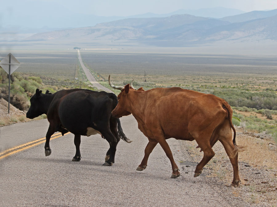
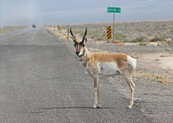
Above: Wildlife abound along the route, including pronghorn, as above, but also wild horses, wild burros,
coyotes, antelope, bighorn, plus cattle, sheep, and horse ranching!
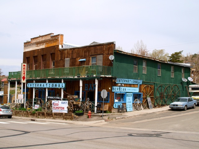
Riders descend the Shoshone Mountains into the Reese River Valley, pulling into Austin, Nevada, ending the third stage of the race for a total distance of 106.41 miles and 5049 feet of elevation gain. If riders or crew want some good food, the International Café, just up the street on the left from the time station, is highly recommended.
Stage 4: Austin to Eureka
Originally founded for gold, Austin never quite panned out and is known, instead, for its abundance of turquoise. Mines riddle the Toyaibe Mountain range around Austin, reaching elevations over 10,000 feet. The town itself is two rows of "charming businesses" and a hotel originally built in Virginia City but moved here, board by board, in 1863.
Austin is left behind with a sharp 3-mile climb out of Austin and into the Big Smoky Valley: a 100-mile expanse which fills with dust and pollen of bloom flora, creating the illusion that the valley is filled with smoke. Riders will descend into this valley’s lowest point at about 15.5 miles into the stage. Then, they will gain a bit over 700 feet in 10 miles where the ride more or less settles into a consistent elevation through Antelope Valley for the remaining miles to the mining time of Eureka. This 70.10 mile stage will gain 2,822 fee, mostly in the first 35 miles.
Above: descending into the Great Smokey Valley on stage three, eastbound
Stage 5: Eureka to Austin
Founded in 1864, Eureka was once Nevada’s second richest mineral producer in the state. It features a remarkable county courthouse, an opera house, and other historic buildings along its main street. For now, however, it serves as the 508’s turn around: riders reverse their trip and race back across the Great Basin which reveals itself to those who ride these miles in a race against time.
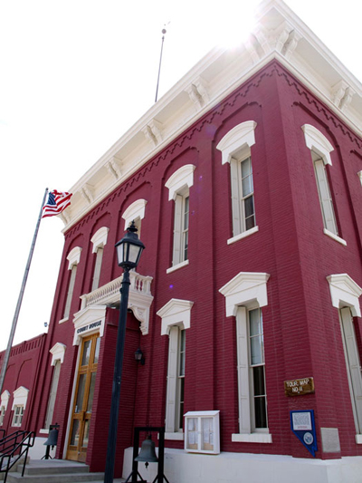
Above: the turn-around spot in Eureka, Nevada
Here, riders may see Nevada’s unique species of fauna: riders have reported riding alongside wild stallions or seeing herds of antelope gazing in the distance.
Riders of this stage will cover 70.10 miles through the Antelope Valley and the big Smokey Valley, a stretch of road that is at a slight incline as the ride progresses. At about mile 46, riders will experience a slight descent from Hickson Summit before ending the stage with 14 miles of climbing into the Toyaibe Mountain Range. The first climb is to Bob Scott Summit (no sign) at 7210’, followed by a quick descent, then the continuing climb to Austin Summit (7474’) at mile 67. From here, watch speed carefully as it’s a very fast, twisty descent into Austin with a speed limit of 25 MPH. Besides not speeding, be sure to keep it quiet, too, as you pass through town. Watch for the time station at the far end of town at the gas station on the left.
Stage 6: Austin to Fallon
Leaving Austin, riders will continue briefly on Hwy 50, then make a left onto the even quieter state route 722. As on the outbound ride, it’s important to keep an eye out here for wild, and domesticated, animals near, or even on, the roadway.
In stage 6 of the race, there are traces of past and present: a windmill on the north side of the highway which is an old Pony Express station. (In fact, riders will parallel the Pony Express Trail during most of the Silver State 508.) The windmill is not the original, but the well beneath is still used today. Then, riders will encounter an old Cottonwood tree filled with shoes. This is not the original shoe tree - that one was cut down a few years ago - but this neighbor tree has taken the burden of holding shoes of highway 50 travelers.
Nearly halfway through this stage, riders will continue over Carroll Summit, after which they will see the Dixie Valley Bombing Range which is still used by the Fallon Naval Air Station with targets that line both sides of Highway 50. On the right is Fairview Peak where the US Government built a small mock city. On October 26, 1963 "Project Shoal" happened: a 12.5 kiloton nuclear bomb was detonated beneath the mock city. There are still foundations that mark the location.
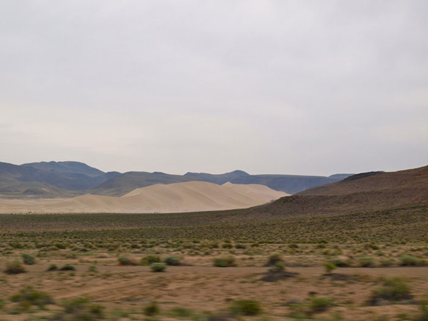
Above: Sand Mountain on Stage Three and Stage Six
At mile 44, riders will begin their descent from Sand Springs Pass. 25 miles from Fallon. Thereafter, riders and crews will enjoy a view off to the right of Sand Mountain, a large dune of sand which is trapped by wind eddies in a valley. There is a rumor that in the 19th century, a Wells Fargo wagon loaded with gold stopped along its route through the state next to Sand Mountain. It remained too long, however, and the mountain moved, covering it. The wagon hasn’t been seen since.
The route passes the outbound time station at Harmon Junction at mile 106.5, but it’s another six miles now into town to the inbound time station in Fallon. Be sure to get all supplies you might need for the rest of the race as you pass through town; it’s a quiet, remote shot back to Reno after this. By the end of this stage, riders will have covered 112.50 miles, gained 2,730 feet, and descended over 5000 feet. There are two stages, but only 72 miles, to go!
Stage 7: Fallon to Silver Springs
This 25.50 mile stage begins in Fallon, home to a "Top Gun" Naval Air Station and the largest town in the region. However, Fallon’s other renown is unexpected: Fallon is known for its uniquely sweet cantaloupe and is one of the largest producers in the US of sweet potatoes as well as alfalfa which is shipped to horses worldwide.
Watch for fast-moving traffic along the first eight miles on Hwy 50 to Leeteville Junction, and be extra vigilant as you merge left across two lanes to make the left to stay on Hwy 50. (Most traffic will continue straight onto Alternate 50 towards Fernley and Reno.) Riders will gain barely 500 feet in elevation from Fallon’s "lush" valley to the next time station in Silver Springs, The time station will not be in its outbound location at the gas and mini-mart (your last for any kind of fuel before the finish line), but just beyond that intersection on the right at the Silver Strike Casino. The restaurant is closed from 900pm to 700am, but the casino is open 24/7!
Stage 8: Silver Springs to Reno
The final leg of the 508 is 46.75 miles that starts with a fast 17.7-mile time trial section, followed by technical ascents and descents to Reno. Riders will leave Silver Springs and follow highway 50 for about 20 miles before turning up the narrow two-lane Six-Mile Canyon.
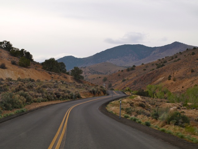
Above: the lower, less steep part of Six Mile Canyon, wesbound towards Virginia City
This climb increases its pitch exponentially over the six miles to Virginia City where riders are offered a brief respite from climbing when they reach town - a town where writer Mark Twain (Samuel Clemens) got his start working for the local paper. He fabricated stories (fiction so close to fact many believed his tall tales) in a stone basement beneath the street where riders ride, high above Reno where the race will end.
This stage continues climbing from Virginia City up a windy two-lane highway to Geiger Summit (6,789 feet before beginning the final descent to Reno. This will be a technical descent of 8.75 miles with many turns as riders see the Truckee Meadows spread out before them in stunning panoramic vistas. Ride carefully and keep in mind that nobody wins a race like this on the final downhill.
The remaining miles of the 508 take riders through Reno’s south meadow: wetlands laced with quiet neighborhoods and business districts to the Atlantis Casino on Virginia Street where the race began. Congratulations! You’ve put 508 miles beneath your wheels and ascended over 20,000 feet!
Above: the finish line at the Atlantis Casino resort: a few lengths of those chains will be removed for riders
to pass through. Support vehicles will overshoot this spot and turn right into the driveway after the crosswalk.
Silver State 508 Route Description by Rebecca Eckland
Click here for Images and Videos of the 2014 Route
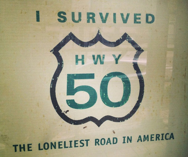
Will YOU survive The Silver State 508 across Nevada's Hwy 50?